


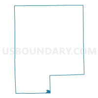
Voting District 0492776000002, Genesee County, Michigan
About
Outline

Summary
| Unique Area Identifier | 596553 |
| Name | Voting District 0492776000002 |
| County | Genesee County |
| State | Michigan |
| Area (square miles) | 1.04 |
| Land Area (square miles) | 0.94 |
| Water Area (square miles) | 0.10 |
| % of Land Area | 90.43 |
| % of Water Area | 9.57 |
| Latitude of the Internal Point | 42.78583130 |
| Longtitude of the Internal Point | -83.69581470 |
Maps

Graphs
Select a template below for downloading or customizing gragh for Voting District 0492776000002, Genesee County, Michigan


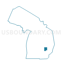
Neighbors
Neighoring Voting District (by Name) Neighboring Voting District on the Map
- Voting District 0492776000001, Genesee County, MI
- Voting District 0492776000003, Genesee County, MI
- Voting District 0492776000004, Genesee County, MI
- Voting District 0938116000002, Livingston County, MI
- Voting District 1253872000003, Oakland County, MI
- Voting District 1256958000001, Oakland County, MI
Top 10 Neighboring County Subdivision (by Population) Neighboring County Subdivision on the Map
- Fenton city, Genesee County, MI (11,746)
- Holly township, Oakland County, MI (11,362)
- Tyrone township, Livingston County, MI (10,020)
- Rose township, Oakland County, MI (6,250)
- Fenton city, Livingston County, MI (10)
- Fenton city, Oakland County, MI (0)
Top 10 Neighboring Place (by Population) Neighboring Place on the Map
Top 10 Neighboring Unified School District (by Population) Neighboring Unified School District on the Map
Top 10 Neighboring State Legislative District Lower Chamber (by Population) Neighboring State Legislative District Lower Chamber on the Map
- State House District 51, MI (107,061)
- State House District 46, MI (100,534)
- State House District 47, MI (96,487)
Top 10 Neighboring State Legislative District Upper Chamber (by Population) Neighboring State Legislative District Upper Chamber on the Map
- State Senate District 15, MI (294,797)
- State Senate District 22, MI (273,659)
- State Senate District 27, MI (256,301)
Top 10 Neighboring 111th Congressional District (by Population) Neighboring 111th Congressional District on the Map
Top 10 Neighboring Census Tract (by Population) Neighboring Census Tract on the Map
- Census Tract 132.04, Genesee County, MI (5,983)
- Census Tract 132.02, Genesee County, MI (5,763)
- Census Tract 1240, Oakland County, MI (5,283)
- Census Tract 1250, Oakland County, MI (3,457)
- Census Tract 7101, Livingston County, MI (2,489)